

Rain and Snow Expected in Massachusetts on Thursday Evening
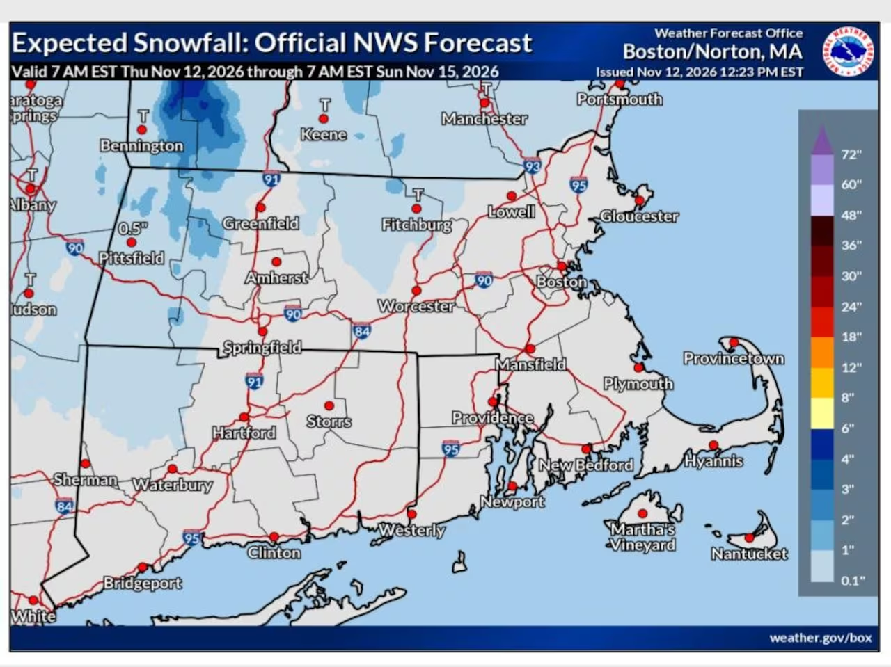
A storm system is set to bring significant rainfall across Massachusetts on Thursday evening, with the potential for wet snow in high-elevation areas of the Berkshires and Worcester Hills, per the National Weather Service.
Weather Conditions Overview
Rainfall is anticipated to commence throughout Massachusetts as temperatures drop to the mid 30s to low 40s overnight. Regions above 1,000 feet, particularly in the Berkshires and Worcester Hills, may experience a transition from rain to snow due to colder temperatures.
Snow Accumulation Forecast
Forecasters do not predict substantial snow accumulation; most towns are expected to see only a light dusting, while areas above 1,500 feet could receive about 1 to 2 inches. Slushy road conditions may develop, especially on secondary routes, though widespread travel disruptions are not expected.
Local Forecasts for Thursday Night
- Boston: Low 41°, rain likely post 5 p.m.
- Hyannis: Low 45°, rain expected after 4 p.m.
- Pittsfield: Low 32°, rainfall anticipated.
- Springfield: Low 37°, rain likely after 5 p.m.
- Worcester: Low 36°, rain projected after 5 p.m.
Friday Weather Outlook
Rain will begin to subside in Northern and Central Massachusetts on Friday morning, with lingering showers expected in Southeastern Massachusetts. Coastal areas may continue to experience rain into Friday afternoon.
The temperature on Friday is forecasted to remain chilly, reaching highs in the upper 30s to low 40s across most regions, with brisk northerly winds enhancing the chill. Berkshire County is expected to be the coldest area, while coastal regions could see temperatures in the low to mid 40s.
Coastal Flooding and Gale Warnings
Residents of Cape Cod and Nantucket might encounter minor coastal flooding during the Friday afternoon high tide. Strong north winds combined with high astronomical tides may lead to brief splash-over on north-facing beaches, although significant flooding impacts are not anticipated.
The National Weather Service has issued gale warnings for most offshore and coastal waters, with wind gusts potentially reaching 35 mph and wave heights increasing to 5 to 10 feet. These warnings will remain in effect until Friday evening.
Small Craft Advisory
A small craft advisory is also active for the waters along the South Shore and South Coast, lasting through Friday evening. Boaters are advised to stay ashore until conditions improve.
Weekend Forecast
Friday night temperatures are expected to drop into the low 40s to mid 30s statewide, with the Berkshires potentially experiencing lows in the mid 20s. On Saturday, maximum temperatures will likely only reach the low to mid 40s, with upper 30s expected in higher elevations. Light, scattered showers may occur Saturday afternoon.
By Sunday, conditions are forecasted to improve, with highs rising into the mid to upper 40s and partly cloudy skies. Lows for Saturday and Sunday nights are expected to fall into the upper 20s to low 30s in Central and Western Massachusetts, and the mid 30s in Eastern regions.
Looking Ahead to Next Week
Next week is expected to bring more favorable weather conditions, with a period of dry and gradually warming temperatures anticipated. Highs may reach the upper 50s to mid 60s by Wednesday.

Chief Editor of Quincy City Beat — Quincy, MA's independent investigative newspaper covering Greater Boston and the entire Commonwealth of Massachusetts with fearless public accountability and free access for all readers.








Discussion about this post